Quantum Safe Bangladesh Dancing with qubits

Climate-smart agriculture · Pre-pilot concept

A decision-support system for one plot at a time

Bangladesh already holds the data. The gap is the last mile: turning registries, forecasts and satellite passes into advice a smallholder can act on this week, in Bangla, on the phone they own.

Duration 365 days Scope 10 districts · 22,065 farmers Field pre-pilot 2,000 farmers · 2 upazilas Hardware procured None

Film

Watch what we're building

A short introduction to the platform: where the data comes from, what the model does with it, and how the advice reaches a farmer holding a feature phone.

Hosted on YouTube. Playback starts only when you press play.

The gap

Assets exist. Advice does not arrive.

BAMIS, DAE-linked farmer registration and agro-meteorological services from BMD and related agencies are all in place. What smallholders still lack is hyper-local, crop-stage-specific guidance at the moment a decision is made.

Three things get in the way: forecasts resolved at district scale rather than field scale, landholdings fragmented across plots that behave differently, and data streams that never meet in a single system.

National strategies — the NAP, the updated NDC — already call for climate-smart agriculture. The implementation gap sits at the last mile.

  • Registries record who a farmer is, not what is growing in a plot this season.
  • Plot-level land records trace to historical surveys and often carry no link to a living cultivator.
  • Advisories are broadcast, so the same message reaches a flooded field and a dry one.
  • Feature phones remain common, so an app-only channel misses much of the audience.

The field GIS step closes the first gap: a DAE officer standing in the plot drops a pin, picks the crop from a standard Bangla list, and the entry syncs to a national geotagged crop layer.

Ground truth

We checked the government's own systems first

Before proposing a new layer, we tested whether existing ones already do the job — screenshots below, not just a description of what we found.

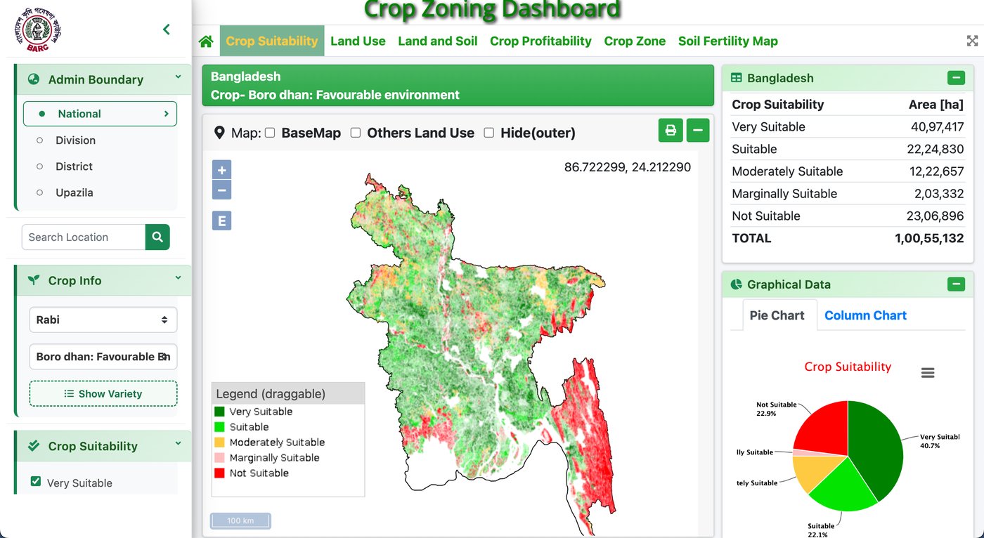
BARC Crop Zoning Dashboard, showing a national map of Bangladesh coloured by crop suitability for Boro dhan, with an area breakdown table alongside

Crop zoning · BARC dashboard

Live and operational, nationally

Real and running today, not a future promise — searchable by division, district and upazila. It answers "where can this crop grow." It does not answer "what is growing on this farmer's plot right now."

Open full size →
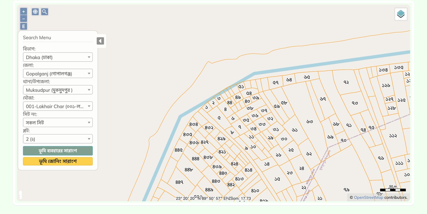
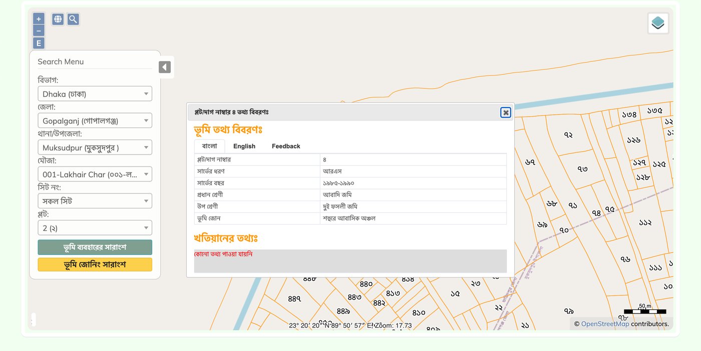
Land ministry plot map search tool, showing plot boundaries and numbers for Muksudpur upazila, searchable by division, district, upazila, mouza and plot number

Land records · Search

Division → Mouza → Plot

The land ministry's plot search is real and searchable. We ran it for a plot in Gopalganj to see what it actually returns.

Open full size →
Land ministry plot record for Plot 8, showing a 1985-90 survey, farmland and dual-residential classification, and a Bangla notice that no khatian ownership record was found

Land records · Result

Plot 8 — 1985–90 survey, no khatian

The record traces to a decades-old survey, classifies the plot as both farmland and urban residential, and returns no khatian (ownership) data at all. Nothing here links it to a living cultivator.

Open full size →

How the pre-pilot closes that second gap

Government registries record who a farmer is; they do not record what is growing in a given plot this season. DAE field officers close that gap directly, on foot.

01 · Open

The field app

A mobile-first web GIS tool, built for a DAE officer standing in the field.

02 · Pin

The plot

GPS-located on the spot — no relying on a 1985 survey line.

03 · Tag

The crop

Chosen from a standard Bangla list of fruits and vegetables.

04 · Sync

Nationally

Links farmer, plot and current crop in one geotagged layer — for the first time.

Why the fields first

Generic advice has a measurable cost

60% Upper bound of the yield gap recorded across crops in Bangladesh.
1.74 Tonnes per hectare — BRRI's estimated rice-specific yield gap.
39–56% Share of potential yield actually realised in rainfed and irrigated rice.
Farmers are not farming badly. They are farming without the hyper-local signal they need at the exact moments — sowing, irrigation, pest pressure — when a district-level forecast is not enough. Sources: Bangladesh Rice Research Institute; peer-reviewed rice yield-gap modelling

Architecture

A hybrid loop with a classical edge

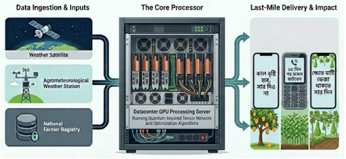
Three layers, acting together as a single national decision brain: ingesting government data and returning one plot's advice, not a district-wide guess. Only the middle layer is quantum-inspired, and it never sits on the path between a farmer and their advice.

End-to-end architecture: weather satellite, agrometeorological weather station and the national farmer registry feed a datacenter GPU processing server running quantum-inspired tensor network and optimisation algorithms, which sends Bangla advisories out to smartphones and feature phones.
From satellites, weather stations and the national farmer registry — through a datacenter GPU processing server running quantum-inspired tensor network and optimisation algorithms — to hyper-local Bangla advisories on every kind of phone.
1,000 pumps across a variable irrigation network — the scheduling problem in one district alone.
13-band Sentinel-2 imagery — the satellite feature space before soil and weather variables are even added.
22,000 individual farmers to optimise advice for, simultaneously, in the pre-pilot scope alone.

Classical statistical tools handle single-variable prediction well. They struggle with combinatorial search across spaces like this one — compute needed grows exponentially as variables are added, not linearly. That is the specific, narrow case the quantum-inspired layer is tested against.

Layer 1 · Classical

Data

Ingests Sentinel-2 optical, Sentinel-1 radar for monsoon cloud cover, IMERG rainfall, BMD forecasts and BAMIS ground truth, joined to the DAE registry and the field crop layer.

Layer 2 · Quantum-inspired

Processing

Prediction: quantum kernel methods and QSVMs run on simulators to separate flood and drought risk zones. Optimisation: irrigation scheduling expressed as a QUBO and solved by annealing, tested against classical solvers.

Layer 3 · Classical

Delivery

A distilled student model emits plain JSON to DAE dashboards, SMS gateways, the automated voice (IVR/OBD) platform and the Bangla app. Ordinary servers or cloud; no quantum dependency at runtime.

Three reasons it's worth a trial

Not a general claim about quantum advantage — three specific, testable ones, each checked against a classical baseline before it's trusted.

Feature selection

Which variables actually matter

Quantum kernels map soil, weather and satellite variables into a higher-dimensional space, looking for separability a classical SVM misses when identifying which of hundreds of variables actually predict crop failure in a specific upazila.

Constrained optimisation

Resource allocation under limits

Irrigation scheduling under shared pump capacity is a resource-allocation problem of the same family as the classic knapsack problem. Annealing explores the space directly rather than approximating it.

Small-data generalisation

Where field data is scarce

Crop-disease niches are often data-scarce. Quantum-inspired teacher models sometimes generalise better there than data-hungry classical deep learning — sometimes; the pre-pilot tests it rather than assumes it.

The two formulations

QUBO and QSVM, spelled out

The two pieces of maths the argument above actually rests on — named in full, not just referenced.

QUBO

Quadratic Unconstrained
Binary Optimization

H = Σᵢ hᵢxᵢ + Σᵢ<ⱼ Jᵢⱼxᵢxⱼ
xᵢ
irrigate plot i, or don't — the binary decision
hᵢ
that plot's water need
Jᵢⱼ
what plots i and j share: a pump, a canal, a transformer

This is the exact shape quantum annealers are built to minimise — the reason irrigation scheduling gets framed this way, rather than the other way round.

QSVM

Quantum Support
Vector Machine

K(x, y) = |⟨φ(x)|φ(y)⟩|²
φ
maps soil pH, moisture, temperature into a quantum state
n qubits
that state lives in a space of dimension 2ⁿ

The point: separating structure without classically building every one of those dimensions by hand.

Method

Quantum-inspired training. Classical deployment.

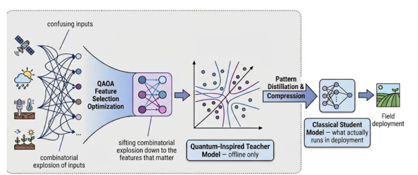
No quantum hardware is procured, and nothing a farmer depends on runs on a quantum machine. Quantum methods are used offline, during training, and only where they beat a strong classical baseline on the same data.

Method diagram: a combinatorial explosion of satellite, weather, soil and crop inputs is narrowed by QAOA feature-selection optimisation, used to train a quantum-inspired teacher model offline, then distilled and compressed into a small classical student model that runs in field deployment.
QAOA feature-selection sifts a combinatorial explosion of inputs down to the features that matter; a quantum-inspired teacher model (offline only) is distilled and compressed into the classical student model that actually runs in field deployment.

Search the combinations

Which mix of satellite bands, soil variables and weather features actually predicts irrigation need in a given upazila? We use QAOA-style feature selection and tensor-network simulation on GPU servers to explore a space that grows exponentially with each variable added.

Train a teacher, distil a student

Quantum kernel methods act as offline teacher models where field data is scarce. Their behaviour is distilled into a small classical student model — the one that actually ships. Every teacher is scored against a strong classical baseline, and we publish the comparison either way.

Deliver it in Bangla, to any phone

The student model runs on ordinary servers and pushes plain-language advice through the channels farmers already use: SMS, automated voice calls for feature phones, and an app for smartphone users. Delivery stays with trusted DAE field officers.

SMS

কাল বৃষ্টি হবে, সার দিও না

Rain tomorrow — hold the fertiliser

Voice call

১৫ দিন পর ফসল কাটবেন

Harvest in about 15 days

App

ক্ষেতে মাটি ভেজা থাকতে সার দিন

Apply fertiliser while the soil is still wet

On honesty about the method: quantum advantage for these workloads is not proven. The pre-pilot is designed to find out, with a classical fallback that is already an improvement on current practice. If the quantum-inspired path adds nothing, that result gets written down too.

After 365 days

What is handed over

A working pre-pilot package, ready for independent evaluation — not a prototype demo.

  • Data pipelines built from the existing registries and open Earth observation feeds.
  • A classical advisory engine, trained with quantum-inspired methods.
  • A tested dashboard and reporting layer for DAE and ministry officials.
  • The Bangla farmer app, plus the SMS and automated voice (IVR/OBD) platforms.
  • The field GIS tool linking farmer, plot and current crop.
  • A validation report on whether hyper-local advisories changed outcomes.
  • Benchmarks: every quantum-inspired result set beside its classical baseline.
  • A scale-up note — including the case for not scaling, if the evidence says so.

Inputs

Built on data the country already has

Nothing here starts with a new national survey. The pre-pilot reads existing registries and open Earth observation, subject to data-sharing agreements with each custodian.

See how it's phased in →
DAE farmer registry
Farmers' Card records — 22,065 farmers across 10 districts in the pre-pilot scope.
BAMIS
Official agro-meteorological advisories and ground truth.
BMD
National weather forecasts.
Sentinel-1 & 2
Radar and 13-band optical imagery; radar matters during monsoon cloud cover.
GPM IMERG
NASA gridded precipitation, for rainfall history and nowcasts.
Field GIS capture
DAE officers pin a plot and tag the crop in Bangla, linking farmer, plot and season.

The 365 days

Four phases, each with a gate

The phases run in order because each one blocks the next: no data agreements, no dataset; no dataset, no model; no model, no field test.

Foundation & mobilisation
Days 1–90

Governance. MoUs with DAE, BMD and BWDB for data access; steering committee formed.
Infrastructure. Cloud sandbox (AWS Braket or IBM Quantum access) plus local GPU servers for tensor-network simulation.
Data audit. Cleaning 22,065 farmer records, verifying geotags, gathering historical yields.
Gate: signed data-sharing agreements and a clean golden dataset, v1.0.

Algorithm development
Days 91–180

Prototyping. Encoding soil moisture and NDVI into quantum feature maps; kernel methods tested against classical baselines.
Formulation. Irrigation scheduling written as a QUBO and solved for a 500-node network.
Backend. Middleware connecting model outputs to the dashboard, target latency under two seconds.
Gate: a documented benchmark result, positive or negative.

Field pre-pilot
Days 181–300

Deployment. Advisories to 2,000 farmers across two upazilas, delivered by DAE officers.
Controlled comparison. One group receives the new advisories; one continues with standard BAMIS advice.
Measurement. Water use, input cost and yield variance tracked across both groups.
Gate: a clean, analysable dataset from the field.

Evaluation & scaling blueprint
Days 301–365

Analysis. Statistical comparison of the two groups, with effect sizes and confidence intervals.
Reporting. A readiness report for the Ministry of Agriculture, published in full.
Handover. A blueprint for national scaling, including integration with existing a2i infrastructure.
Gate: a scale, adjust or stop recommendation supported by the data.

Risk

What could go wrong, and the answer to it

RiskLikelihoodImpactResponse
No quantum speed-up found Medium High Fall back to quantum-inspired classical methods — tensor networks — which already improve on the legacy pipeline. The negative result is published.
Data access denied or delayed Medium Critical MoU signing is a Phase 1 blocker, not a parallel task. Open satellite and rainfall products serve as the fallback layer.
Farmers do not trust the advice Low Medium Delivery through DAE officers farmers already know, voice messages in local dialect, and advice that names its reason.
Cloud and compute overrun High Medium Simulation-first policy with hard budget caps; paid quantum backends reserved for final validation runs only.

Cost posture: the pre-pilot is scoped well under one million USD because it procures no quantum hardware and builds on registries that already exist. Quantum-inspired workloads run on GPU servers; cloud quantum backends are used sparingly and by the hour.

National alignment

Designed against commitments already made

SDGs 2 & 13Food security and climate action.
NDCNationally Determined Contributions, updated.
NAPNational Adaptation Plan — climate-smart agriculture.
Delta Plan 2100Water management and agricultural resilience.

Governance

Farmer data stays in Bangladesh

Sovereignty is a design constraint, not a policy paragraph added at the end.

Localisation
All personally identifiable farmer data remains on servers physically located in Bangladesh, or in government cloud.
Anonymisation
Only anonymised, aggregated feature vectors are sent to any international compute provider. No names and no exact addresses leave the country.
Purpose limits
Registry data is used for advisory generation and evaluation only, under the terms of each data-sharing agreement.
Compliance
Aligned to Bangladesh's data protection framework as it develops, and reviewed with each custodian agency before deployment.

Project roles

Who is accountable for what

RoleResponsibility
Project oversightStrategic direction, and coordination with DAE, BMD and ministry counterparts.
Lead scientist, quantumDesigns the QML circuits and the tensor-network simulations; owns benchmark integrity.
Agri-domain expertValidates every advisory rule, and translates model output into language a farmer trusts.
Data engineering leadAPI integration with BAMIS and BMD; owns the data lake and pipeline uptime.
Field coordinatorRuns the pilot upazilas and the DAE officer feedback loop.

The sceptic's questions

Fair challenges, answered plainly

Classical AI can already predict. Why quantum at all?
For most prediction, classical models are the right answer and we use them. The interesting case is interconnected optimisation — if this farmer irrigates now, pressure drops on the shared line and the next field suffers. Quantum-inspired search is a candidate there. Candidate, not conclusion: it competes against a classical solver on the same problem, and loses openly if it loses.
Do you need a quantum computer to run this?
No. Nothing farmer-facing touches quantum hardware. Quantum-inspired methods run as simulations on GPU servers during offline training; cloud quantum backends are used only for bounded validation runs.
Is this just another digitisation project?
It differs in where it starts. There is no new national data collection: the pre-pilot reads existing registries and open satellite products, and spends its effort on the join between them and on the last mile to the farmer.
What happens if the pre-pilot fails?
The evaluation report is published either way, and the recommendation can be to stop. A pre-pilot that produces an honest negative result at this budget has done its job.

Bring us a district

The fastest way to start is one upazila, one crop cycle, and a clear question about what a farmer should have done differently.

Immediate next steps

1Approve the pre-pilot scope — well under a million USD, no new hardware procurement.
2Nominate focal points from DAE and BMD to sign the data-sharing MoUs — the one step on the critical path this team cannot do alone.
3Open recruitment for the lead quantum scientist role.
The ask is narrow: a small task force inside the Ministry of Agriculture to fast-track those MoUs. Everything else in this plan, the team can start on its own.